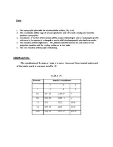
Land Surveying - Surveying Calculus

Curs
8/10 (1 vot)
Domeniu: Construcții
Conține 1 fișier: pdf
Pagini : 101 în total
Cuvinte : 17071
Mărime: 5.25MB (arhivat)
Puncte necesare: 0

Extras din curs

Application nb.1

Surveying calculations

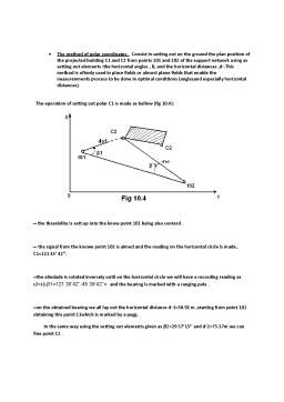
The ensemble of operations in order to obtain plans and maps is known as surneying.Because during land surveying, the calculations involve a large volume of work, it is proper that the way of doing these calculations to be well studied.

Application theme

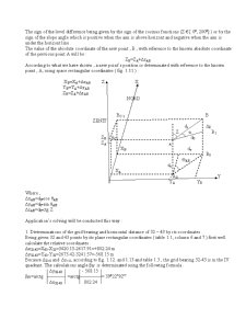
In order to establish the position of points, depending on a reference coordinates system, related to the Earth’s surface, it is necessary the knowledge of some essential surveying calculations.

Datums

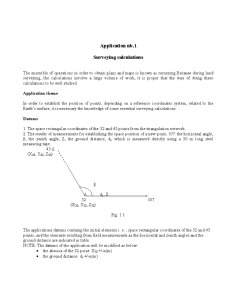
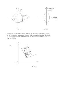
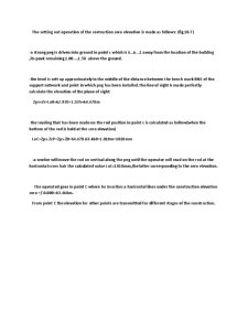
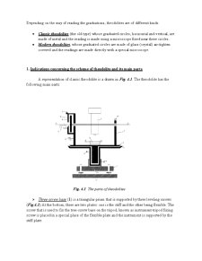
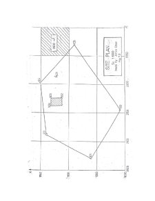
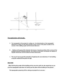
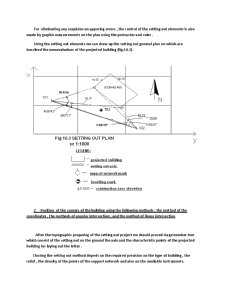
1. The space rectangular coordinates of the 32 and 43 points from the triangulation network.

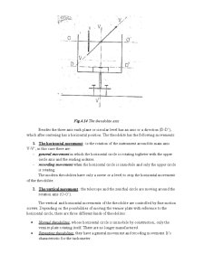
2. The results of measurements for establishing the space position of a new point, 107: the horizontal angle, β, the zenith angle, Z, the ground distance, di, which is measured directly using a 50 m long steel measuring tape.
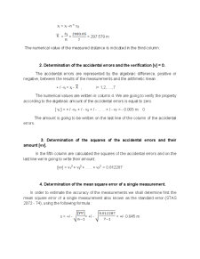
43 Δ

(X43, Y43, Z43)

β

Δ di , Z o

32 107

(X32, Y32, Z32)

Fig. 1.1

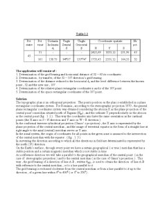
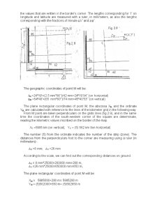
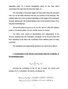
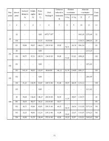
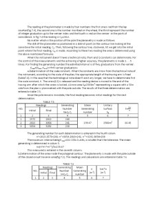
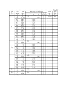
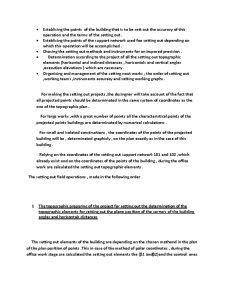
The applications datums containg the initial elements i. e. , space rectangular coordinates of the 32 and 43 points, and the elements resulting from field measurements as the horizontal and zenith angles and the ground distance are indicated in table.

NOTE: The datums of the application will be modified as below: the abscisa of the 32 point: X32 +/-n(m) the ground distance: di +/-n(m)
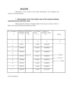
Table 1.1

Pct.

statie

Pct.

vizat

Distanta

Inclinata

di

Unghi

Zenital

Z

Unghi

Orizontal

β

Coordonate spatiale

X Y Z

Nr.

pct.

45

51

101

-

138.75

-

94g51c

-

131g74c

2421,69 1833,12 231,96

1735,43 2351,12 164,55

43

32

The application will consist of :

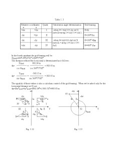
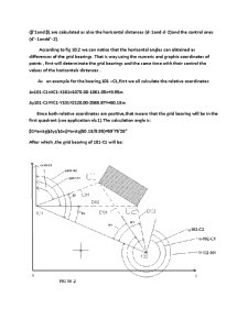
1. Determination of the grid bearing and horizontal distance of 32 – 43 its coordinates .

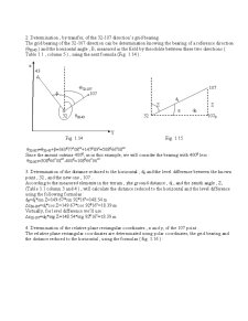
2. Determination , by transfer, of the 32 – 107 direction’s grid bearing .

3. Determination of the distance reduced to the horizontal do and the level difference between the known point , 32 and the new one , 107 .

4. Determination of the relative plane rectangular coordinates x and y of the 107 point .

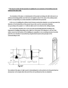
5. Determination of the space rectangular coordinates of the 107 point .
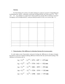
Solution

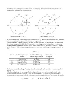
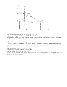
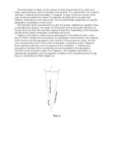
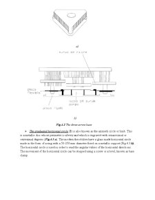
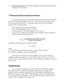
The topographic plan is an orthogonal projection . The points position on the plan is established in a plane rectangular coordinates system . For Romania , according to the stereographic projection 1970 , the general plane rectangular coordinates system was obtained considering the abscisa X as the plane projection of the central point’s meridian situated north of Fagaras (Ngo) , and the ordinate Y perpendicularly on the abscisa in the central point (fig . 1. 2 ) . This way the coordinates axis have the same orientation as the cardinal points (the X axis on S – N direction and Y axis on W – E direction.) .

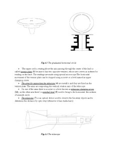
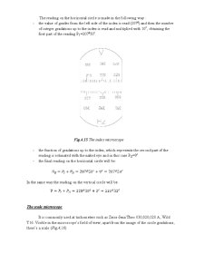
In the conformal traverse cylindrical projection (Gauss’ s projection) , the X axis is represented by the plane projection of the central meridian , and the image of terrestrial equator in the form of a straight line at right angle to the axial (central) meridian serves as Y axis.

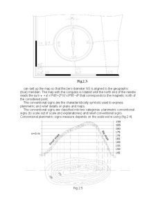
In the zonal system, the origin of coordinates for all points in the given zone is assumed to the intersection of the central meridian with the equator . ( fig . 1. 3 ).

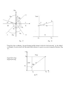
In surveying the direction according to which all the directions in field are determinated is represented by the north ( N ) direction .

On the Earth’s surface , through every point we have a certain geographical ( or true ) meridian that has a stable position and a certain magnetic meridian which is not stable in time .

As a reference direction we will take a parallel to the geographical meridian of the central point ( in the case of stereographic projection ) and to the central meridian ( in the case of Gauss’s projection ) . This way , the grid bearing of a direction of line A-B , written θAB , is used to obtain the direction of line A-B with reference to the central meridian , or to a line parallel to it .

The grid bearing is reckoned clockwise from the central meridian or from a line parallel to it up to the direction , of a given line within 0g to 400g ( or 0o to 350o)
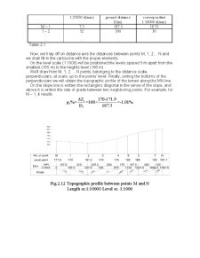
Preview document

Land Surveying - Surveying Calculus - Pagina 1
Land Surveying - Surveying Calculus - Pagina 2
Land Surveying - Surveying Calculus - Pagina 3
Land Surveying - Surveying Calculus - Pagina 4
Land Surveying - Surveying Calculus - Pagina 5
Land Surveying - Surveying Calculus - Pagina 6
Land Surveying - Surveying Calculus - Pagina 7
Land Surveying - Surveying Calculus - Pagina 8
Land Surveying - Surveying Calculus - Pagina 9
Land Surveying - Surveying Calculus - Pagina 10
Land Surveying - Surveying Calculus - Pagina 11
Land Surveying - Surveying Calculus - Pagina 12
Land Surveying - Surveying Calculus - Pagina 13
Land Surveying - Surveying Calculus - Pagina 14
Land Surveying - Surveying Calculus - Pagina 15
Land Surveying - Surveying Calculus - Pagina 16
Land Surveying - Surveying Calculus - Pagina 17
Land Surveying - Surveying Calculus - Pagina 18
Land Surveying - Surveying Calculus - Pagina 19
Land Surveying - Surveying Calculus - Pagina 20
Land Surveying - Surveying Calculus - Pagina 21
Land Surveying - Surveying Calculus - Pagina 22
Land Surveying - Surveying Calculus - Pagina 23
Land Surveying - Surveying Calculus - Pagina 24
Land Surveying - Surveying Calculus - Pagina 25
Land Surveying - Surveying Calculus - Pagina 26
Land Surveying - Surveying Calculus - Pagina 27
Land Surveying - Surveying Calculus - Pagina 28
Land Surveying - Surveying Calculus - Pagina 29
Land Surveying - Surveying Calculus - Pagina 30
Land Surveying - Surveying Calculus - Pagina 31
Land Surveying - Surveying Calculus - Pagina 32
Land Surveying - Surveying Calculus - Pagina 33
Land Surveying - Surveying Calculus - Pagina 34
Land Surveying - Surveying Calculus - Pagina 35
Land Surveying - Surveying Calculus - Pagina 36
Land Surveying - Surveying Calculus - Pagina 37
Land Surveying - Surveying Calculus - Pagina 38
Land Surveying - Surveying Calculus - Pagina 39
Land Surveying - Surveying Calculus - Pagina 40
Land Surveying - Surveying Calculus - Pagina 41
Land Surveying - Surveying Calculus - Pagina 42
Land Surveying - Surveying Calculus - Pagina 43
Land Surveying - Surveying Calculus - Pagina 44
Land Surveying - Surveying Calculus - Pagina 45
Land Surveying - Surveying Calculus - Pagina 46
Land Surveying - Surveying Calculus - Pagina 47
Land Surveying - Surveying Calculus - Pagina 48
Land Surveying - Surveying Calculus - Pagina 49
Land Surveying - Surveying Calculus - Pagina 50
Land Surveying - Surveying Calculus - Pagina 51
Land Surveying - Surveying Calculus - Pagina 52
Land Surveying - Surveying Calculus - Pagina 53
Land Surveying - Surveying Calculus - Pagina 54
Land Surveying - Surveying Calculus - Pagina 55
Land Surveying - Surveying Calculus - Pagina 56
Land Surveying - Surveying Calculus - Pagina 57
Land Surveying - Surveying Calculus - Pagina 58
Land Surveying - Surveying Calculus - Pagina 59
Land Surveying - Surveying Calculus - Pagina 60
Land Surveying - Surveying Calculus - Pagina 61
Land Surveying - Surveying Calculus - Pagina 62
Land Surveying - Surveying Calculus - Pagina 63
Land Surveying - Surveying Calculus - Pagina 64
Land Surveying - Surveying Calculus - Pagina 65
Land Surveying - Surveying Calculus - Pagina 66
Land Surveying - Surveying Calculus - Pagina 67
Land Surveying - Surveying Calculus - Pagina 68
Land Surveying - Surveying Calculus - Pagina 69
Land Surveying - Surveying Calculus - Pagina 70
Land Surveying - Surveying Calculus - Pagina 71
Land Surveying - Surveying Calculus - Pagina 72
Land Surveying - Surveying Calculus - Pagina 73
Land Surveying - Surveying Calculus - Pagina 74
Land Surveying - Surveying Calculus - Pagina 75
Land Surveying - Surveying Calculus - Pagina 76
Land Surveying - Surveying Calculus - Pagina 77
Land Surveying - Surveying Calculus - Pagina 78
Land Surveying - Surveying Calculus - Pagina 79
Land Surveying - Surveying Calculus - Pagina 80
Land Surveying - Surveying Calculus - Pagina 81
Land Surveying - Surveying Calculus - Pagina 82
Land Surveying - Surveying Calculus - Pagina 83
Land Surveying - Surveying Calculus - Pagina 84
Land Surveying - Surveying Calculus - Pagina 85
Land Surveying - Surveying Calculus - Pagina 86
Land Surveying - Surveying Calculus - Pagina 87
Land Surveying - Surveying Calculus - Pagina 88
Land Surveying - Surveying Calculus - Pagina 89
Land Surveying - Surveying Calculus - Pagina 90
Land Surveying - Surveying Calculus - Pagina 91
Land Surveying - Surveying Calculus - Pagina 92
Land Surveying - Surveying Calculus - Pagina 93
Land Surveying - Surveying Calculus - Pagina 94
Land Surveying - Surveying Calculus - Pagina 95
Land Surveying - Surveying Calculus - Pagina 96
Land Surveying - Surveying Calculus - Pagina 97
Land Surveying - Surveying Calculus - Pagina 98
Land Surveying - Surveying Calculus - Pagina 99
Land Surveying - Surveying Calculus - Pagina 100
Land Surveying - Surveying Calculus - Pagina 101

Conținut arhivă zip

  • Land Surveying - Surveying Calculus.pdf

Ai nevoie de altceva?