Extras din referat
Leveling methods
For studying and projecting engineering works the largest usefulness have the maps and plans on which are represented both planimetric details and the relief forms. Leveling is completing the planimetric surveys with the forms of relief giving thus a complete image of the earth’s surface that is represented on the plan.
Aplication Theme
For modernizing a street there has been made a leveling by geometric leveling from the mid-point between bench marks the elevation of which are know, combined with method of the cross section. We’re asked for the determination of the elevation of point, drawing up the longitudinal profile of the streets and the transversal profiles of the streets.
Data
1. The elevation of the support bench marks, A and B
2. The horizontal distances measured directly in the field between the points of the traverse and also from the axis of the road to each point in transversal section.
3. Readings on the road at the horizontal cross hair from each leveling station point.
The application will consist of:
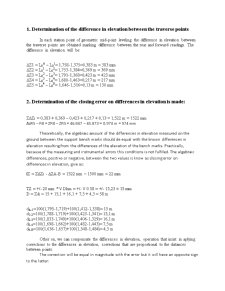
1. Determination of the difference in elevation between the traverse point.
2. Determination of the closing error on differences in elevation and their compensation.
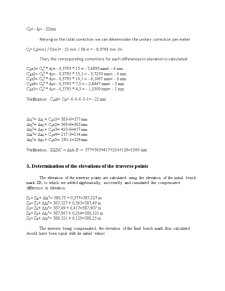
3. Determination of the elevation of the traverse point.
4. Determination of the elevation of the points of the longitudinal profile.
5. Drawing up the longitudinal profile of the streets axis, having the length scale as 1:1000 and the elevation scale 1:100.
6. Drawing up the transversal profiles, having both the length and elevation scale as 1:100.
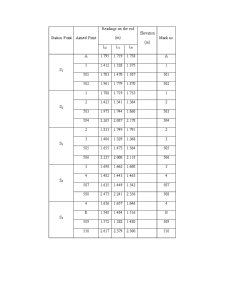
Station Point Aimed Point Readings on the rod
(m) Elevation
(m) Mark no.
L2 L1 L0
S1 A 1.795 1.719 1.758 A
1 1.412 1.338 1.375 1
501 1.703 1.470 1.587 501
502 1.961 1.779 1.870 502
S2 1 1.788 1.719 1.753 1
2 1.423 1.341 1.384 2
503 1.973 1.744 1.860 503
504 2.265 2.087 2.178 504
S3 2 1.833 1.749 1.791 2
3 1.406 1.329 1.368 3
505 1.655 1.473 1.564 505
506 2.235 2.000 2.118 506
S4 3 1.698 1.662 1.680 3
4 1.482 1.443 1.463 4
507 1.635 1.449 1.542 507
508 2.473 2.241 2.356 508
S5 4 1.636 1.657 1.646 4
B 1.548 1.484 1.516 B
509 1.572 1.388 1.480 509
510 2.617 2.379 2.500 510
Preview document


Conținut arhivă zip
- Leveling Methods.doc
Alții au mai descărcat și


Caiet de practică Executarea lucrărilor de tencuială , zugrăveală şi vopsitorii Tencuiala este stratul de finisaj aplicat pe suprafaţa brută a...

Număr de ordine: 37 1. Date iniţiale : - grosime placă : hpl= 16 cm - înălţime nivel : Hnivel = 2.80 m - dimensiuni în plan a plăcii : 3.95 x...

1.3 Coordonarea modulară şi toleranţele Coordonarea dimensională în construcţii reprezintă metoda de stabilire a dimensiunilor şi poziţiilor...

1. OBIECTUL TEMEI Obiectul temei reprezintă modelarea fizică a fenomenului de convecţie forţată în interiorul conductelor circulare. Se va modela...
Te-ar putea interesa și

Application theme In order to make a corect reprezentation in plan of a topografic surface there are necesary some basic topografic calculus...

Application nb.1 Surveying calculations The ensemble of operations in order to obtain plans and maps is known as surneying.Because during land...