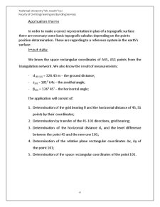
Land Surveying - Solved Assignments

Proiect
8/10 (1 vot)
Domeniu: Construcții
Conține 8 fișiere: doc, docx
Pagini : 63 în total
Cuvinte : 9505
Mărime: 2.37MB (arhivat)
Puncte necesare: 6
Toate cele 8 teme rezolvate din cadrul proiectului de Topografie al studentilor de anul 2 de la Fac de Constructii din Iasi,specializarea - inginerie civila (predare in limba engleza). Proiectul este la fel pentru fiecare in parte doar ca difera numarul de ordine si profilul transversal dat de profesor pe harta la tema nr. 2.

Extras din proiect

Application theme

In order to make a corect reprezentation in plan of a topografic surface there are necesary some basic topografic calculus depending on the points position detarmination. These are regarding to a reference system in the earth's surface:

Imput data:

We know the space rectangular coordinates of Δ45, Δ51 points from the triangulation network. We also know the result of measurements:

- di 45-101 = 328.43 m – the ground distance;

- z101 = 101g 64c – the zenithal angle;

- β101 = 126g 45c – the horizontal angle;

The application will consist of:

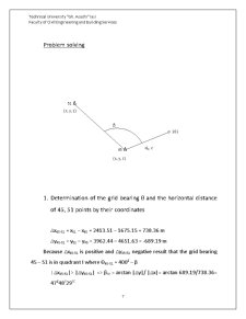
1. Determination of the grid bearing θ and the horizontal distance of 45, 51 points by their coordinates;

2. Determination by transfer of the 45-101 directions, grid bearing;

3. Determination of the horizontal distance do and the level difference between the point 45 and the new one 101;

4. Determination of the relative plane rectangular coordinates Δx, Δy of the point 101;

5. Determination of the space rectangular coordinates of the point 101.

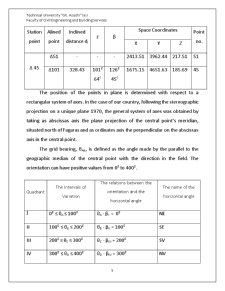
Station point Alined point Inclined distance di z β Space Coordinates Point no.

X Y Z

Δ 45 Δ51 - - - 2413.51 3962.44 217.51 51

Δ101 328.43 101g 64c 126g 45c 1675.15 4651.63 185.69 45

The position of the points in plane is determined with respect to a rectangular system of axes. In the case of our country, following the stereographic projection on a unique plane 1970, the general system of axes was obtained by taking as abscissas axis the plane projection of the central point’s meridian, situated north of Fagaras and as ordinates axis the perpendicular on the abscissas axis in the central point.

The grid bearing, θAB, is defined as the angle made by the parallel to the geographic median of the central point with the direction in the field. The orientation can have positive values from 0g to 400g.

Quadrant The Intervals of Variation The relations between the orientation and the horizontal angle The name of the horizontal angle

I 0g ≤ θA ≤ 100g θA - βI = 0g NE

II 100g ≤ θB ≤ 200g θB - βII = 100g SE

III 200g ≤ θC ≤ 300g θC - βIII = 200g SV

IV 300g ≤ θD ≤ 400g θD - βIV = 300g NV

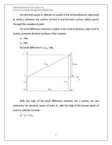
The absolute quote or altitude of a point is the vertical distance, expressed in meters, between the surface of level 0 and the level surface which passes through the considered point.

The level difference between 2 points is the vertical distance, expressed in meters, between the level surfaces of the 2 points.

Preview document

Land Surveying - Solved Assignments - Pagina 1
Land Surveying - Solved Assignments - Pagina 2
Land Surveying - Solved Assignments - Pagina 3
Land Surveying - Solved Assignments - Pagina 4
Land Surveying - Solved Assignments - Pagina 5
Land Surveying - Solved Assignments - Pagina 6
Land Surveying - Solved Assignments - Pagina 7
Land Surveying - Solved Assignments - Pagina 8
Land Surveying - Solved Assignments - Pagina 9
Land Surveying - Solved Assignments - Pagina 10
Land Surveying - Solved Assignments - Pagina 11
Land Surveying - Solved Assignments - Pagina 12
Land Surveying - Solved Assignments - Pagina 13
Land Surveying - Solved Assignments - Pagina 14
Land Surveying - Solved Assignments - Pagina 15
Land Surveying - Solved Assignments - Pagina 16
Land Surveying - Solved Assignments - Pagina 17
Land Surveying - Solved Assignments - Pagina 18
Land Surveying - Solved Assignments - Pagina 19
Land Surveying - Solved Assignments - Pagina 20
Land Surveying - Solved Assignments - Pagina 21
Land Surveying - Solved Assignments - Pagina 22
Land Surveying - Solved Assignments - Pagina 23
Land Surveying - Solved Assignments - Pagina 24
Land Surveying - Solved Assignments - Pagina 25
Land Surveying - Solved Assignments - Pagina 26
Land Surveying - Solved Assignments - Pagina 27
Land Surveying - Solved Assignments - Pagina 28
Land Surveying - Solved Assignments - Pagina 29
Land Surveying - Solved Assignments - Pagina 30
Land Surveying - Solved Assignments - Pagina 31
Land Surveying - Solved Assignments - Pagina 32
Land Surveying - Solved Assignments - Pagina 33
Land Surveying - Solved Assignments - Pagina 34
Land Surveying - Solved Assignments - Pagina 35
Land Surveying - Solved Assignments - Pagina 36
Land Surveying - Solved Assignments - Pagina 37
Land Surveying - Solved Assignments - Pagina 38
Land Surveying - Solved Assignments - Pagina 39
Land Surveying - Solved Assignments - Pagina 40
Land Surveying - Solved Assignments - Pagina 41
Land Surveying - Solved Assignments - Pagina 42
Land Surveying - Solved Assignments - Pagina 43
Land Surveying - Solved Assignments - Pagina 44
Land Surveying - Solved Assignments - Pagina 45
Land Surveying - Solved Assignments - Pagina 46
Land Surveying - Solved Assignments - Pagina 47
Land Surveying - Solved Assignments - Pagina 48
Land Surveying - Solved Assignments - Pagina 49
Land Surveying - Solved Assignments - Pagina 50
Land Surveying - Solved Assignments - Pagina 51
Land Surveying - Solved Assignments - Pagina 52
Land Surveying - Solved Assignments - Pagina 53
Land Surveying - Solved Assignments - Pagina 54
Land Surveying - Solved Assignments - Pagina 55
Land Surveying - Solved Assignments - Pagina 56
Land Surveying - Solved Assignments - Pagina 57
Land Surveying - Solved Assignments - Pagina 58
Land Surveying - Solved Assignments - Pagina 59
Land Surveying - Solved Assignments - Pagina 60
Land Surveying - Solved Assignments - Pagina 61
Land Surveying - Solved Assignments - Pagina 62
Land Surveying - Solved Assignments - Pagina 63

Conținut arhivă zip

  • Land Surveying - Solved Assignments
    • Topografie lucrarea 1.docx
    • Topografie lucrarea 2.doc
    • Topografie lucrarea 3.doc
    • Topografie lucrarea 4.docx
    • Topografie lucrarea 5.doc
    • Topografie lucrarea 6.docx
    • Topografie lucrarea 7.docx
    • Topografie lucrarea 8.doc

Ai nevoie de altceva?