Extras din proiect
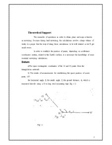
Theoretical Support
The ensemble of operations in order to obtain plans and maps is known as surveying. Because during land surveying, the calculations involve a large volume of work, it is proper that the way of doing these calculations to be well studied so we’ll get small errors.
In order to establish the position of points, depending on a reference coordinates system, related to the Earth’s surface, it is necessary the knowledge of some essential surveying calculations.
Datum
a)The space rectangular coordinates of the 32 and 43 points from the triangulation network.
b) The results of measurements for establishing the space position of a new point, 107:
the horizontal angle, β, the zenith angle, Z, the ground distance, di, which is measured directly using a 50 m long steel measuring tape (fig 1.1)
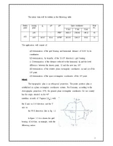
The initial data will be written in the following table
Station point Aiming point di Zg βg Space coordinates Point No.
X [m] Y [m] Z [m]
Δ32 Δ43 -- -- 0g00g 3420.15 2763.42 149.12 43
○107 145.67 92.16 147g89c 2613.91 3241.57 93.82 32
The application will consist of:
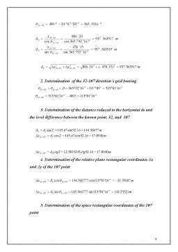
a)Determination of the grid bearing and horizontal distance of 32-43 by its coordinates.
b)Determination, by transfer, of the 32-107 direction’s grid bearing.
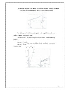
c) Determination of the distance reduced to the horizontal d0 and the level difference between the known point, 32 and the new one, 107.
d)Determination of the relative plane rectangular coordinates Δx and Δy of the 107 point.
e)Determination of the space rectangular coordinates of the 107 point.
Hint:
The topographic plan is an orthogonal projection. The points position plan is established in a plane rectangular coordinates system. For Romania, according to the stereographic projection 1970, the general plane rectangular coordinates for our country has the origin situated on the 46° meridian at north of Fagaras ( ), with the X axis on S-N direction and the Y axis on
the W-E diresction like in fig. 1.2
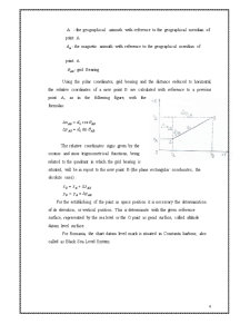
In figure 1.3 it is shown the grid bearing of AB line, as example, with the following notion:
A - the geographical azimuth with reference to the geographical meridian of point A
- the magnetic azimuth with reference to the geographical meridian of point A
- grid Bearing
Using the polar coordinates, grid bearing and the distance reduced to horizontal, the relative coordinates of a new point B are calculated with reference to a previous point A, as in the following figure, with the formulas:
Preview document


Conținut arhivă zip
- Topografie.doc
Te-ar putea interesa și

1.)TEODOLIT ELECTRONIC Seria DT Aplicatii Teodolitul electronic seria DT are un sistem incremental optic de citire a unghiurilor cu ajutorul...

CAPITOLUL I AMPLASAREA GEOGRAFICA SI LOCALIZAREA OBIECTIVULUI PROIECTAT 1.1 C. V. Localitatea Baru este situată în partea sudică a județului...

1. Introducere Conform etimologiei cuvantului (din limba greaca, topos = loc si graphien = a desena, a scrie), Topografia este una din stiintele...

1.)TEODOLIT ELECTRONIC Seria DT Aplicatii Teodolitul electronic seria DT are un sistem incremental optic de citire a unghiurilor cu ajutorul...

Capitolul I Localizarea geografică şi economico – administrativă 1.1. Localizarea perimetrului. Perimetrul de exploatare Petrila este situat în...

Cap.1 Lucrari topografice la proiectarea constructiilor industrial si civile. 1.1.1. Retele de sprijin topografice legate de proiectarea...

1. Scopul topografiei. Definitie Topografia este o ramura a geodeziei care se ocupa cu tehnica masuratorilor unei portiuni a scoartei Pamantului,...

§1. Noţiuni generale despre topografie şi cartografie Harta se utilizează în multe activităţi umane, fiind folosită mai ales în cercetările...