Cuprins
- CHAPTER I: KEY INFORMATION ABOUT KENYA 2
- 1.1. Climate 3
- 1.2. Places to see 4
- 1.2.1. Parks and Reserves in Kenya 4
- 1.2.2. National Museums and Monuments 7
- 1.2.3. Beaches 8
- 1.2.4. The Great Rift Valley 8
- 1.2.5. Cities 9
- 1.3. Places to eat and drink 10
- 1.3.1. Restaurants and bars 10
- 1.3.2. Local specialities 11
- 1.4. Places to sleep 12
- 1.5. Entertainment 13
- 1.5.1. Popular events 13
- 1.5.2. Tourism products 14
- 1.5.2.1. Wildlife Safari in Kenya 14
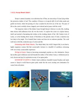
- 1.5.2.2. Kenya Beach Safari 15
- 1.5.2.3. Adventurer's Paradise 16
- 1.5.2.4. Cultural Safari 17
- 1.5.3. Nightlife 18
- 1.6. Transportation 19
Extras din proiect
CHAPTER II: HELPFUL KENYA TRAVEL TIPS 21
BIBLIOGRAPHY 24
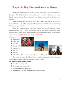
Chapter I: Key information about Kenya
Kenya, officially known as the Republic of Kenya, is a country in East Africa that lies on the equator. With the Indian Ocean to its south-east, it is bordered by Tanzania to the south, Uganda to the west, South Sudan to the north-west, Ethiopia to the north and Somalia to the north-east.
Kenya has a land area of : 580,367 km2 (224,081 sq mi): land: 569,140 km2 (219,750 sq mi) and water: 11,227 km2 (4,335 sq mi); and a population of nearly 41 million, representing 42 different peoples and cultures.
Kenya has a young population, with 73% of residents aged below 30 years, due to rapid population growth from 2.9 million to 41 million over the last century.Kenya's rising urban population has a diverse ethnic background whose people are variedly fluent in their mother tongues and the two official languages – English and Swahili.
Ethnic groups:
- Kikuyu 22%,
- Luhya 14%,
- Luo 13%,
- Kalenjin 12%,
- Kamba 11%,
- Kisii 6%,
- Meru 6%,
- other African 15%, non-African (Asian, European, and Arab) 1%
The country is named after Mount Kenya, a significant landmark and second among Africa's highest mountain peaks. The geography of Kenya is diverse.
The country is divided into four regions:
- the arid deserts of the north;
- the savannah lands of the south;
- the fertile lowlands along the coast;
- and highlands in the west, where the capital Nairobi is situated.
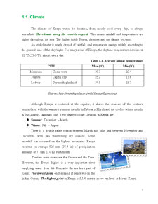
1.1. Climate
The climate of Kenya varies by location, from mostly cool every day, to always warm/hot. The climate along the coast is tropical. This means rainfall and temperatures are higher throughout the year. The further inside Kenya, the more arid the climate becomes.
An arid climate is nearly devoid of rainfall, and temperature swings widely according to the general time of the day/night. For many areas of Kenya, the daytime temperature rises about 12 °C (53.6 °F), almost every day.
Tabel 1.1. Average annual temperatures
CITY Max (°C) Min (°C)
Mombasa Costal town 30.3 22.4
Nairobi Capital city 25.2 13.6
Lodwar Dry north plainlands 34.8 23.7
Source: http://en.wikipedia.org/wiki/Kenya#Etymology
Although Kenya is centered at the equator, it shares the seasons of the southern hemisphere: with the warmest summer months in February-March and the coolest winter months in July-August, although only a few degrees cooler. Seasons in Kenya are:
- Summer: December – March
- Winter: July – August
There is a double rainy season between March and May and between November and December, with two intervening dry seasons. Some snowfall has occurred on the highest mountains. Kenya receives on average 925 mm (36.4 in) of precipitation annually or 77 mm (3.0 in) each month.
The two main rivers are the Galana and the Tana. However, the Ewaso Ng'iro is a very important river supplying water from Mt. Kenya to the northern part of Kenya. The lowest point on Kenya is at sea level on the Indian Ocean. The highest point on Kenya is 5,199 meters above sea level at Mount Kenya.
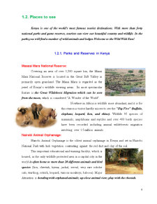
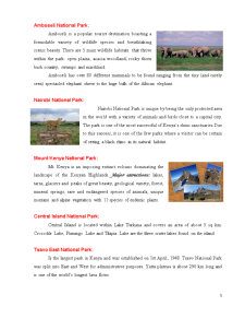
1.2. Places to see
Kenya is one of the world's most famous tourist destinations. With more than forty national parks and game reserves, tourists can view our beautiful country and wildlife. In the parks,you will find a number of wild animals and lodges.Welcome to the Wild Wild East!
Preview document


Conținut arhivă zip
- Kenya - Famous Tourist Destination.docx
Alții au mai descărcat și


Santorini - the mysterious and romantic island of Greece Santorini is considered one of the most beautiful islands in Greece and one of the most 3...

Strategies for identifying and measuring risk can help treasury personnel develop a sound diversification policy Before a risk profile can be...

Ideal vacation PARIS PARIS Paris is the capital of France. The city is located in the central-north of the country, the River Seine, downstream...

The Evolution Of Computer Science The birth of computers and information technology goes back many centuries. The development of mathematics led...

The day of September 11th 2001 will remain as a dark day in history. All people know about this day and what happened at this date. On this day,...
INTRODUCTION Essential facts about Argentina Geert Hofstede analysis over Argentina and the Latin American countries BUSINESS ETIQUETTE...