Cuprins
- I. Introduction
- 1.1 Objectives
- 1.2 Methodology
- II. Landscape
- 2.1 Geology
- 2.2 Soil
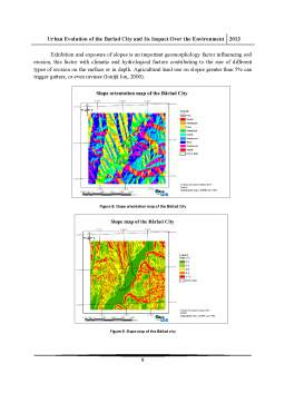
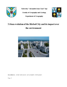
- 2.3 Geomorphology
- 2.4 Hydrology
- 2.5 Meteorology
- 2.6 Flora and land use
- III. Urban evolution between 1887-2012
- 3.1 Until 1887
- 3.2 Between 1887-1906
- 3.3 Between 1906-1944
- 3.4 Between 1944-1983
- 3.5 Between 1983-1990
- 3.6 Between 1990-2012
- IV. Types of waste
- 4.1 Agro-tehnic waste
- 4.2 Industrial waste
- 4.3 Household waste
- 4.4 Sanitary waste
- 4.5 Waste oil
- V. Impact over the enviroment
- 5.1 Air pollution
- 5.2 Soil pollution
- 5.3 Water pollution
- VI. Conclusions
- Bibliography
Extras din proiect
I.Introduction
Since the 19th century, the urban evolution has seen a major interest in human geography, this is due to the industrial revolution. Knowing the site of a city and its evolution is a complex study space, influenced by historical events, political and economic influences. With the evolution of urban space, the landscape has changed due to disinterest population resulting to a series of negative actions have destroyed ecosystems. With the urban evolution the ecosystems had suffered, leading to the disappearance of species of plants and animals.
Bârlad city has had a particularly urban interwar period, when Berladuium Fair began an urbanization by expanding housing that led to cutting orchards and vineyards, and the disappearance of agricultural land were in the plot, which led to a series negative effects on the environment. Communist period led to the industrialization of Barlad in the northern part of the city, which led to intense environmental air pollution.
By analyzing the evolution of urban space can cause major disruptions that occurred while stemming from chaotic homes, industrial areas, farms and other facilities that affect the environment.
1.1 Objectives
The study " Urban evolution of the Bârlad City and its impact over the enviroment" aims to analyze the evolution of urban Bârlad from 1887 to 2012, and the determination of the main pollutants and their environmental impact through a synthetic study.
Determination of urban evolution will be achieved through analysis of topographic maps, satellite maps, orthophotoplans and where they will observe developments in the city, and how the city has evolved, while space farming, fruit growing and viticulture disappeared from localities. All spatial analyzes of maps and knowing the city will determine the main pollutants and their environmental impact.
1.2 Methodology
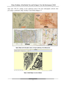
For this study " Urban evolution of the Bârlad City and its impact over the enviroment" we used topographic maps of the years 1887, 1906, 1944, 1987, 1990; orotofotoplan in 2005 and satellite images from Google Earth. Maps were processed in TNT Mips 6.9, Global Mapper 13 and ArcMap 10. Vector database was performed using TNT Mips 6.9 and 1:25,000 topographic maps year 1983 for carrying out the numerical model of the land, hydrographic network, their processing is performed using ArcMap 10 and Global Mapper 13.
Figure 1:Maps used in the project (source: www,geo-spatial.org, www.oldmaps.com)
Figure 2: Global Mapper 13; vector database
Figure 3: Vector database processing in TNT Mips 6.9
Figure 4: Map layout using ArcMap 10
To achieve and determinate urban evolution had been used all the above mentioned cartographic materials and their processing in TNT Mips 6.9 and ArcMap 10.
For maps of soils, geology and land use were used vector datasets from www.geo-spatial.org, datasets had been processed using ArcMap 10 software and Global Mapper 13.
For the study on the determinate the main types of waste had been used 2005 orotofotoplans, Bârlad city limits been extracted by using the Global Mapper 13, and the field study and knowledge about types of polluters were used for making data processing using TNT Mips 6.9 and ArcMap 10.
Preview document


Conținut arhivă zip
- Urban Evolution of the Barlad City and Its Impact Over the Environment.docx