Cuprins
- Introduction
- 1.The chemistry of petroleum – what is petroleum?
- 2.Exploring for oil and gas
- 3. Summary about petroleum
- References
Extras din referat
Introduction
Oil and gas seeps have been known since earliest recorded history. Sticky black asphalt was used by the Babylonians as a roofing material, the ancient Egyptians used it to preserve their dead, and Noah supposedly caulked his Ark with it. In Azerbaijan gas seeps have burned for centuries, and therefore it is perhaps surprising that the world's first major underground oilfield was discovered in Pennsylvania, USA only as recently as 1859. That discovery launched an era in which the world became increasingly reliant on cheap energy provided by oil and gas, a reliance assured by the invention of the internal combustion engine in the late 19th century. Only now, as the issues of long-term sustainability and climate change become more apparent, are we beginning to think about unshackling ourselves from that dependency.
1.The chemistry of petroleum – what is petroleum?
Petroleum is the term for a complex mixture of hydrocarbons and lesser quantities of other organic molecules containing sulphur (S), oxygen (O), nitrogen (N) and some metals. Hydrocarbons are compounds that contain only hydrogen (H) and carbon (C) atoms and the number of carbon atoms in a compound determines its physical properties. For example, simple compounds such as methane (CH4), ethane (C2H6), propane (C3H8) and butane (C4H10) all have boiling temperatures below 0 °C and are therefore gases under ambient (surface temperature and pressure) conditions. Larger, more complex hydrocarbon compounds ranging from pentane (C5H12) to hexadecane (C16H34) are liquids under ambient conditions, whilst even larger compounds with a high molecular weight form waxy solids.
The molecular arrangement of hydrocarbon compounds is highly variable. The most commonly occurring forms are chemically stable, so-called saturated compounds known collectively as paraffins and cycloparaffins. A second group, in which the bonding arrangement is more complex and potentially less chemically stable, comprises unsaturated compounds called aromatics and alkenes. Aromatic compounds such as toluene (C6H5CH3) rarely amount to more than 15% of petroleum but they may impart a pleasant odour, hence their name.
Petroleum occurs naturally in several forms: natural gas – mainly gaseous hydrocarbons but also containing variable amounts of carbon dioxide; a liquid, called crude oil, that typically contains a very wide range of hydrocarbon compounds; and solid bitumen. Bitumen contains the heaviest (in the sense of high molecular weight) and most complex hydrocarbon compounds found in petroleum, and they are relatively enriched in oxygen, sulphur and nitrogen. The composition of typical petroleum samples are shown in Table 1. Note that oxygen is a significant impurity in bitumen, but is commonly found only in trace amounts in crude oil and natural gas. In contrast, nitrogen is negligible in bitumen and crude oil, but may constitute up to 15% in natural gas.
Table 1: Composition of typical petroleum samples.
2.Exploring for oil and gas
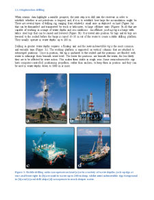
It would be prohibitively expensive to explore for oil and gas on a random basis, and most of the effort would be wasted. When geological knowledge was far more limited than it is today, most of the discoveries were beneath quite obvious signs of petroleum seepage at the surface. Eventually, such easy targets ran out, although some are still being discovered. The key ingredients for petroleum accumulation which we have discussed in this unit were gleaned from the knowledge gained by drilling such targets and examining the geology around them. As more has been learned, increasingly sophisticated methods have been developed that increase the odds of making a discovery in less obvious situations. This section covers some of those methods and describes how an exploration well is drilled and evaluated.
2.1.1 Surface detection methods
Field mapping is a well established technique that has contributed to the discovery of billions of barrels of petroleum. In the pioneering era of onshore exploration the search for anticlinal structures at shallow, drillable depths usually began with the recognition of an overlying part of such a structure at the surface. These days, with ready access to various forms of subsurface data, field mapping is more commonly used to assess the structural style of a basin and to provide analogues for concealed reservoirs or source rocks. Far from being an outdated technique, modern fieldwork is becoming increasingly sophisticated as digital data collection is underpinned by Global Positioning Systems (GPS), satellite imagery and digital terrain models. In Norway's Lofoten Islands a detailed analysis of onshore fault and other structural patterns is being extrapolated offshore in order to calibrate three-dimensional (3-D) seismic data in unexplored portions of the Norwegian continental shelf.
2.1.2 Remote sensing methods
Remote sensing involves gathering information of many kinds at a distance from the object of investigation: it gives a regional picture and helps sort the likely areas to follow up from those much larger areas that are less favourable. Satellite, gravity and magnetic methods (see below) are commonly used during the early phase of exploration when a sedimentary basin, or at least a substantial part of it, is not known in sufficient detail to deploy more expensive methods. Their interpretation is simple and can be done relatively cheaply in the office. Satellite images take the form of spectral data over a wide range of wavelengths, from the visible through infrared to microwave (radar). They can sometimes detect unknown petroleum seepages. On land, the presence of a seep is often associated with a change in vegetation or soil colour, especially if the seep is of crude oil, whilst in the offshore setting rising gas bubbles may draw deep water to the surface, giving a cool thermal image. Alternatively, satellites can provide photographic imagery with an extraordinarily good resolution, sufficient to map rock exposures, analyse topography, and to locate roads, habitations and so on.
Gravity surveys are often used to analyse sedimentary basins at the regional scale. Because sedimentary rocks usually have a lower density than crystalline rocks, thick sequences of relatively low-density sediments effectively reduce the Earth's gravitational force and they are characterised by regional gravity lows. Gravity data may be collected on land, at sea or by air and they are particularly useful in areas of difficult terrain, such as jungles and deserts, where access is difficult. Regional airborne magnetic surveys can also be used to define the shape and gross structure of a basin and they are often acquired in tandem with gravity surveys. Magnetic rocks cause perturbations in the Earth's magnetic field, whereas non-magnetic rocks have little effect. Sediments are typically poorly magnetic because they do not contain large amounts of iron-rich minerals, whereas igneous rocks such as volcanic lavas often do. So sedimentary basins characteristically have a low, uniform magnetic signature that contrasts markedly with the highly variable magnetic anomalies associated with metamorphic basement rocks and near-surface volcanic intrusions. Where faults juxtapose rocks with different magnetic properties at depth, the faults show up as distinctive linear features.
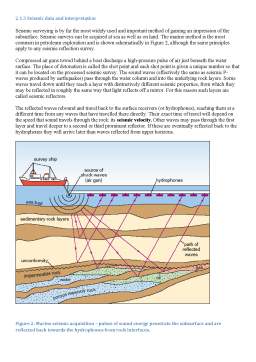
2.1.3 Seismic data and interpretation
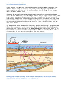
Seismic surveying is by far the most widely used and important method of gaining an impression of the subsurface. Seismic surveys can be acquired at sea as well as on land. The marine method is the most common in petroleum exploration and is shown schematically in Figure 2, although the same principles apply to any seismic reflection survey.
Compressed air guns towed behind a boat discharge a high-pressure pulse of air just beneath the water surface. The place of detonation is called the shot point and each shot point is given a unique number so that it can be located on the processed seismic survey. The sound waves (effectively the same as seismic P-waves produced by earthquakes) pass through the water column and into the underlying rock layers. Some waves travel down until they reach a layer with distinctively different seismic properties, from which they may be reflected in roughly the same way that light reflects off a mirror. For this reason such layers are called seismic reflectors.
The reflected waves rebound and travel back to the surface receivers (or hydrophones), reaching them at a different time from any waves that have travelled there directly. Their exact time of travel will depend on the speed that sound travels through the rock: its seismic velocity. Other waves may pass through the first layer and travel deeper to a second or third prominent reflector. If these are eventually reflected back to the hydrophones they will arrive later than waves reflected from upper horizons.
Preview document


Conținut arhivă zip
- About Petroleum.doc
Alții au mai descărcat și

Introduction The British Museum is one of the great museums of the world and, after Blackpool Beach, is Britain's most popular tourist attraction...


Strategies for identifying and measuring risk can help treasury personnel develop a sound diversification policy Before a risk profile can be...

The Evolution Of Computer Science The birth of computers and information technology goes back many centuries. The development of mathematics led...

The day of September 11th 2001 will remain as a dark day in history. All people know about this day and what happened at this date. On this day,...

Part Three: Gapped Text You are going to read a magazine article about a trip to Australia. Seven paragraphs have been removed from the article...

INTRODUCTION Essential facts about Argentina Geert Hofstede analysis over Argentina and the Latin American countries BUSINESS ETIQUETTE...
Te-ar putea interesa și

Introduction The investments in petroleum exploration and production (E&P) projects are frequently of medium/long term, with valuable embedded...


I. INTRODUCTION A new future in automotive transportation is steadily approaching. This future will be one in which light and heavy vehicles are...

Earth one of the planets in the solar system, the third in distance from the sun and the fifth largest of the planets in diameter. The mean...


Abstract: The innovation process is a complex phenomenon characterized by several stages reaching from basic research up to the penetration of the...

1. History of taxes in France The tax system has never been united in France. There have always been an extreme diversity in collection, the base,...
