Extras din referat
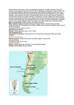
General Description: Araucarias Biosphere Reserve is situated in the southern part of the volcanic Andean chain, in south-central Chile. The biosphere reserve includes two national parks: ‘Conguillío-Los Paraguas’ which constitute the core area, and the ‘Alto Bio-Bio’ forest reserve constituting the buffer zone. The Conguillío is characterised by forests of Nothofagus with Araucaria (A. araucana) forests, rivers and lakes. The Alto Bío-Bío has Andean steppe with pasture lands and agroecosystems. The most prominent species of the biosphere reserve is the Araucaria, also called ‘Monkey Puzzle’ or Chilean Pine, which has been declared a natural monument in Chile. Four species of Nothofagus are encountered, as well as Podocarpus andinus and Austrocedrus chilensis. Among the mammal species, the ’pudu’ (Pudu pudu) and ‘guanaco’ (Lama guanicoe) are particularly noteworthy. The very rare marsupial Dromiciops australis occurs within the biosphere reserve, and both the avifauna and herpetofauna are very rich. Areas which have been grazed in the past or subject to forest exploitation are all set-aside as ecosystem restoration zones. The Alto Bio-Bio Forest Reserve (buffer zone) has a population of about 20 families (1980) engaged in pastoralism. Around 25,000 national and 1,700 international tourists annually visit the core area. The biosphere reserve offers a great potential for scientific research and studies have been undertaken, particularly on the reintroduction of the guanaco (Lama guanicoe). Some environmental education activities also take place
Major ecosystem type: Mixed mountain and highland systems
Major habitats & land cover types: P. N. Conguillío: Forests of Nothofagus; Araucaria (A. araucana) forests; rivers and lakes
R. N. Alto Bío-Bío: Andean steppe (Estepa alto andina); pasture lands, agroecosystems
Location: Parque Nacional Conguillío:
38°30' to 38°50'S; 70°50' to 71°08'W
Reserva Nacional Alto Bío-Bío:
38°30' to 38°46'S; 71°30' to 71°55'W
Area (hectares): Total=93,833
Altitude (metres above sea level): +800 to +3,124
Year designated:1983
Administrative authorities: Corporación Nacional Forestal CONAF Jefe Regional Unidad de Gestión Patrimonio Silvestre
Brief description:Meteorology and climate
Chemical parameters of the river Bío-Bío
Volcanological observations to predict and detect eruptions
Conservation of woodpeckers (Carpintero grande)
Aquatic birds
Impact of domestic animals
Specific variables...
Abiotic: Abiotic factors, climate, meteorology.
Biodiversity: Birds, conservation, freshwater/inland water, methodologies, volcanic/geothermal systems/volcano
Socio-economic: Livestock and related impacts/Overgrazing, natural hazards.
Integrated monitoring: Impact and risk studies/Environmental impact
CABO DE HORNOS
General description:Cabo de Hornos Biosphere Reserve, the first nominated in Chile in more than 20 years, is located in the extreme south of the American continent, comprising marine areas, islands and forested coast. It includes an extensive and remote area of temperate forests, the sub-antarctic or sub-polar forests of Magellanic Chile, that recently have been identified as one of the 37 most pristine ecoregions in the world. This ecoregion corresponds to one of the unique areas where non-fragmented or altered temperate forests are conserved. The Archipelago of Cabo de Hornos is one of the few insular groups that remain free of human impact. The mosaic of terrestrial ecosystems includes evergreen broadleaf forests, deciduous forests, alpine habitats with formations of cushion plants and lichens, a complex of tundra formations ranging from Juncaceae wetlands to Sphagnum peat bogs, glaciers and snowdrifts, and a series of freshwater ecosystems. These ecosystems are located in an insular system, in the middle of an intricate system of fjords, channels, estuaries and bays. In this regional heterogeneity several types of intertidal systems are distinguished with extensive meadows and belts of brown seaweed (Macrocystis pyrifera). Recent analysis has shown that the sub-antarctic ecoregion of Magellanic Chile includes the greatest diversity of non-vascular floral species in Chile, and constitutes a hotspot of bryophyte diversity.
The region to the south of 50°S also represents a hotspot of invertebrate and marine mammal diversity, with cetaceans such as the Peale's dolphin (Lagenorhynchus australis) and black dolphin (Cephalorhynchus eutropia), and occasional visits by killer whales (Orcinus orca) and antarctic minke whales (Balaenoptera bonaerensis). The presence of penguins are remarkable, principally the Magellanic penguin (Spheniscus magellanicus) and the rockhopper penguin (Eudyptes crestatus).
The core areas are constituted of the Cabo de Hornos and Agostini National Parks, which in spite of their proximity, are not interconnected. The biosphere reserve will contribute to initiate scientific education, research and conservation programs in both national parks and establish a biological corridor between them.
Cabo de Hornos represents the southernmost territory in the world with pre-Columbian populations, since the territory corresponds to the ancestral territory of the Yagán people. Some 2.200 people live in the transition area with a concentration in Puerto Williams. The resident civil population mainly includes the indigenous community of Yagán descending from the first colonists. The main economic activities are artisanal fishery, public services, diverse small-scale commercial activities and some cattle raising. The Yagán people constitute a nomad culture that has inhabited the southern end of the American continent at 56°S. They live in the coastal sectors, navigating the channels of Cabo de Hornos and the sub-antarctic archipelago region to the south of the Tierra del Fuego. Today it is the most threatened of the Chilean indigenous cultures. The Biosphere Reserve supports economic and human development through an 'alliance between science and tourism to promote sustainable development'. It also provides advice to stimulate the sustainable use of marine and silvoagricultural natural resources on which the extractive and productive activities are based that constitute the base of the local economy.
Major ecosystem type: Temperate forest; Sub-polar evergreen rainforest; Coastal marine systems
Major habitats & land cover types: Intertidal and sub-marine forests with brown seaweed Macrocystis pyrifera and Lessonia vadosa, L. flavescens and L. trabeculata; Intertidal zones with macroalgae communities dominated by Lessonia nigrescens and Durvillaea antartica; Intertidal zones and rocky bottoms formed by great quarry stones with D. antartica and L. nigrescens in exposed intertidal zones and with M. pyrifera, L. vadosa and L. flavescens in more protected areas; Intertidal and sub-tidal zones formed by fine sediments (sands and muds) dominated by Enteromorpha sp. and Ulva sp.; Intertidal and steep rocky subtidal zones with algae species such as Adenocystis utricularis, Porphira sp. and Polysiphonia sp.; Pelagic - demersal habitat
Location: 55°15'S; 69°30'W (Central point)
54°09'S; 70°92'W (Northern limit)
54°67'S; 72°50'W (Western limit)
56°18'S; 67°28'W (Southern limit)
55°21'S; 66°06'W (Eastern limit)
Area (hectares):4.884.273
Altitude (metres above sea level): about -500 to +2,234
Year designated: 2005
Administrative authorities: Gobernación de la Provincia Antártica Chilena
Preview document


Conținut arhivă zip
- Rezervatiile Biosferei din Chile.doc
Te-ar putea interesa și

CAPITOLUL I – INTRODUCERE ÎN NOŢIUNEA DE PLAM 1.1. Ce este un PLAM? Un Plan Local de Acţiune pentru Mediu (PLAM) sau LEAP - Local Environmental...

CAPITOLUL 1: APA 1.1. Calitatea apei fluviului Dunărea pe teritoriul Rezervaţiei Biosferei "Delta Dunării" Dunãrea, ecosistemul deltaic precum şi...

Introducere Tema aleasă spre analiză se numeşte „REZERVAŢIA BIOSFEREI DELTA DUNĂRII” şi cuprinde mai multe capitole şi subcapitole în care se...

PREFAŢĂ Motivul pentru care am ales această temă, pentru lucrarea de disertație, este în principal fascinaţia pe care am acumulat-o datorită unor...

Introducere Capitolul:Date cu caracter general 1.1 Incadrare in teritoriu-zonificare. Delta Dunării (3446 km²), aflată în mare parte în...

I. Rezervaţiei Biosferei Delta Dunării - aspecte introductive 1.1. Importanţa Rezervaţiei Biosferei Delta Dunării Prin sintagma de „Rezervaţie...

1.Identificarea zonei si alegerea tipului de amenajare 1.1 Coordonatele zonei Zona propusa pentru amenajare se afla în comuna Maliuc, judetul...

„Cat vezi cu ochiul, verde, papurisul Se-ndoaie-n vantul serii, fosnitor. Din cand in cand si-arata luminisul Un ochi de apa moarta. Un cocor...